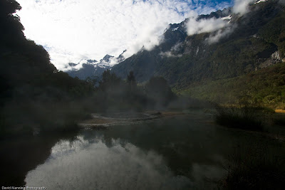
Friday, November 7, 2014

Where the Weta Lives

Dave and I hadn’t been for a climb together for what seemed like an age. We were both pretty keen but a close inspection of the weather on Friday afternoon put a halt to any two day trips that could have been. We were faced with a marginal window, on Sunday, for a climb east of the divide. It seems we had become the dreaded weekend warriors.


Steeple Peak.


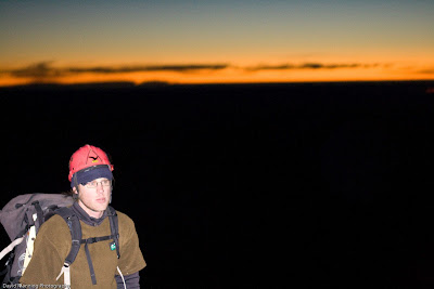
Cruising the McKenzie on Saturday evening we shared looks of doubt as first the sky was ablaze with a quintessential nor’west sunset followed by rain and high wind whilst rounding Lake Ohau. Perhaps we should have stayed in Christchurch like everyone else?

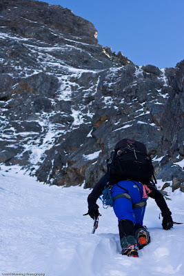
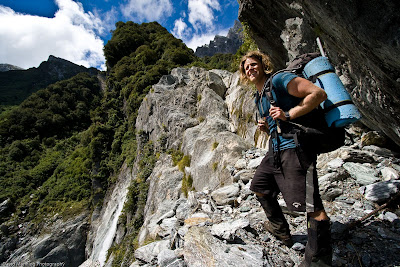
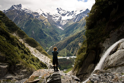
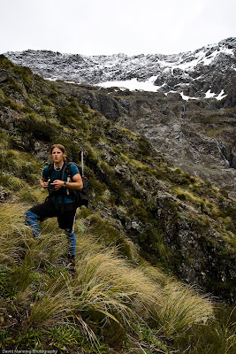
We bivvied at the road end and headed up the North Temple at first light. I’d been inspired to climb Steeple Peak after friends of mine, Glen Case, Brian Creswell and Stu the Scotsman had climbed it in a day, just a week before. They, like us, accessed the head of the South Temple via the North Temple. This choice of access turned out to be a bad call. Gaining Gunsight Pass from the North Temple was spooky to say the least. The combination of fresh rock fall and rotten snow accompanied by the gushing water wouldn’t lead me to recommend this route in late spring!


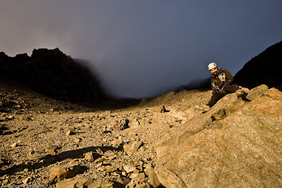
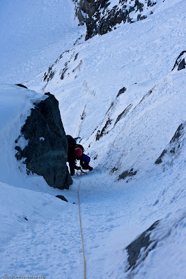
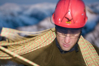
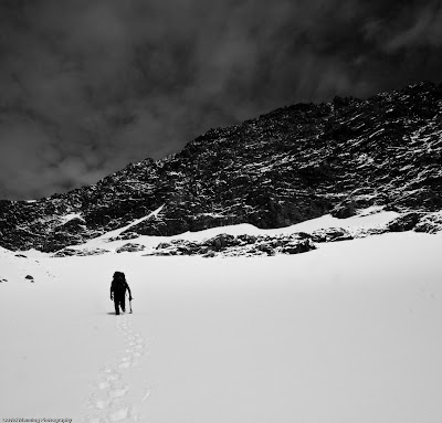
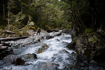
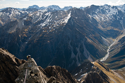
Kieran descending into the South Temple from Gunsight Pass.

We entered the South Temple around lunch time and made our way over to the base of Weta Prowl. The slabs were still slightly wet from the previous night’s precipitation. However, by the time we roped up the rock was dry. There was only a slight breeze and the sky was clear. Our marginal window had turned into a bluebird day. Now we were glad we hadn’t stayed in Christchurch like everyone else.


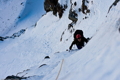
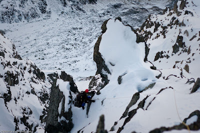
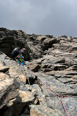
Easy pitches at the bottom of the climb.

As it turns out, one can easily scramble up the first pitch to a good belay ledge, we wasted little time protecting this section. The following three pitches consisted of pleasant, easy slab climbing. Although it was somewhat chossy there was a reasonable amount of natural gear and we were able to use the full length of our ropes.

At about half height Dave said he saw a weta. The name couldn’t be more appropriate.


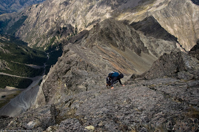
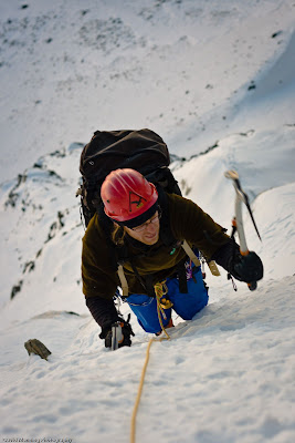
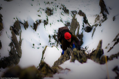
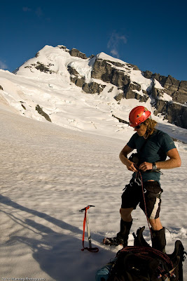
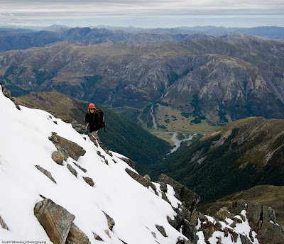
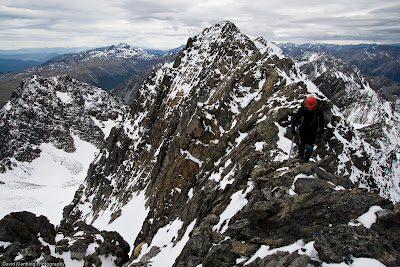
Kieran just below the crux section.

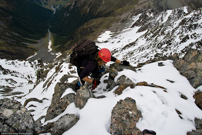
The last pitch on the face included some thinking climbing. I led through a section of small bulges followed by a fantastic stint of crimpy slab climbing. This was a welcome change from the easy but chossy sections lower down. This pitch ended just below the summit ridge.


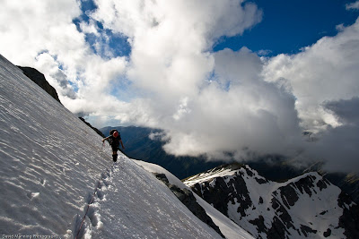
Fun climbing on the upper ridge.

Normally one would expect ridges to be nerve wrecking and time consuming in this part of the world. So, Dave and I were pleasantly surprised to find the ridge consisted of solid rock. The final two pitches were sublime, exposed and solid! If nothing else Weta Prowl is worth climbing for these two pitches alone.


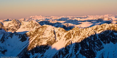
The view north towards MCNP.

At the summit we were greeted by a paraglider who circled us a couple of times, an odd end to the route, but certainly entertaining. The scramble to the col, South of Steeple peak is straight forward; in fact the remainder of the trip should have been so.


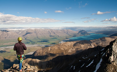
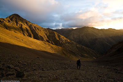
Looking towards Lake Ohau from the summit.

Dave forgot to bring the batteries for his head torch. We walked at a sluggish pace once it got dark. I can only imagine this was very painful for Dave, given the routine tripping on obstacles. In fact we were so slow that we didn’t get back to the car until after 1am on Monday morning.

The drive home was done in shifts and we took a 20 minute power nap in Geraldine, around sunrise. I don’t think either of us got any real sleep before going into work. Ah, the life of the weekend warrior.

Weta Prowl is an excellent low grade, multi pitch, alpine rock route and it can be done in more comfortable fashion by making use of South Temple hut or bivvying in the upper valley. The rock quality is good with reasonable natural gear and the climb is set in a stunning location. This is a real must do weekend climb!
Read more

Monday, May 13, 2013

The Ornery Goat


“Have you seen any goats?”

 “Nah, but I’ve smelt them” 

I joked about the four-legged creatures. The Seal Skin label on my neoprene booties sparked a train of thought. Maybe we didn’t need to carry any food. We could just go Navy Seal and hunt down a goat with our ice axes. Steve was not impressed. He suggested that goats are much more agile than any human. Point taken. 

It was early on Saturday morning and my feet were freezing despite the booties. We’d struck it lucky though. A cool, high had cloaked the South Island for a few days. The cold air mass ensured the Hodder River was in low flow. Travel was fast. Fingers crossed the ice had formed. 

That afternoon we were destined for a high camp at the Tappy-Alarm Saddle. Thankfully, there was barely a step to plug in the consolidated snow pack. However, we were still warm from lugging our gear up the 2000m of vertical gain. Lengthy stints without conversation ensued as we made our way up the gently angled, Staircase Stream. The sun slid behind a ridge as we arrived at the saddle. Instant cold set in and our camp became a freezing one. Not to worry though. Perched high above the Clarence River, the location more than made up for the temperature. There was also the added bonus of anticipation of the climb ahead.

Our high camp - photo: Steve Fortune

The plan was to sidle the southern aspect of point 2711 and eye up a potential route before descending into the basin below the South Face of Tapuae-o-Uenuku. Although we never got the view we wanted.

The south face, our line starts behind the right hand bottom end of the prominent buttress - photo: Steve Fortune

Dropping into the basin we passed some slabby looking ice lines and found ourselves beneath a deep gut. Steve suggested we have a go at that. I agreed.

The gut - photo: Steve Fortune


Steve on the first pitch - photo: Kieran Parsons

Spindrift poured over the imposing walls that flanked our chosen line. Like a funnel, the onslaught of crystals concentrated on the iced up gut. The climbing was fantastic. Two pitches with a touch of chimneying and sections of steep ice saw us through to the middle snowfield. I was also surprised to get a thread on the second pitch. The speckled, metallic grey and light brown rock was unfamiliar but it took reasonable gear.

Kieran seconding pitch 1 - photo: Steve Fortune

Kieran on pitch 2 - photo: Steve Fortune

We switched to simil-climbing mode at the snowfield. Once Steve reached the upper headwall he made for a “super ice runnel” that breaks the final obstacle. The runnel was nothing other than superb. First time sticks made the climbing enjoyable, whilst a series of steps kept one engaged.

The awesome ice runnel is the obvious line on the left - photo: Steve Fortune

With the ocean stretching to the horizon the position of our climb was magnified. I had not climbed an ice route in view of the Pacific Ocean before. What a place to be. This was surly one of those elusive moments of Alpinism. Never quite captured by a lens or expressed with ink. 

We exited the runnel and entered the upper snowfield. The line then delivered us direct to the summit trig. We shook hands and agreed that the route was surprisingly good and the view was stunning.

Steve at the summit - photo: Kieran Parsons

On Sunday afternoon, with haste, Steve and I made our way back to the road. Again conversation abandoned us as we settled into a rapid pace. We were focused on making it out of the riverbed before dark. 

Back at the car and relieving our shoulders of packs we couldn’t help but marvel at the fact that a quality route, on a popular and heavily trafficked peak, had not been climbed until now. It just goes to show that one never knows what gems may be hidden out there. 

To cap it all off the little tuck shop in Seddon was still open. The drive home wasn’t a hungry one. 

The Ornery Goat, Steve Fourtune and Kieran Parsons, September 2012


This article can also be found in the NZ Alpine Journal 2012.

Note: there is potentially a good (unclimbed) line on the south face of Mt Alarm.
Read more

Monday, April 4, 2011

We aren't Alpine Rock Jocks

The guide book says it “could be a project for keen alpine rock jocks”. I’d seen the South face slabs of Pinnacle, 2120m, in early spring 2010. The addition of snow and the odd slither of ice might have impaired my judgement.


Looking at the choice rock on Pinnacle


When I returned in late summer 2011 with Dave Manning and Vaughan Snowdon I was somewhat disappointed by the rock I saw.

We spent the night in Boulder Forks Hut only 50 minutes walk from where we parked. The next morning saw us take the easy walk up Boulder Stream in somewhat confusing topography, as the stream arcs around the many and complicated ridges of Pinnacle. Vaughan vigorously questioned his ‘native guide’, me, and I assured him I was just as confused by the lay of the land the first time I’d come here. However, I really did know where we were going. As we rounded the last bend in the valley at approximately 1,100m the mountain came into view.

Approaching the slabs we eyed up a crack system, approximately in the centre of the south face, which could provide a direct line and spit us onto the ridge after (maybe) four pitches. The closer we got the less we liked what we saw. There were areas that looked ok but nothing linked up and the higher one’s eyes went the looser the rock looked.

On the drive up to Marlborough from Christchurch I had been informed by the others that, if the climbing was no good, I’d be left in Blenheim (because this was my idea). Don’t take it personally, Blenheimites, but that isn’t a prospect I welcomed.

Eventually we scrambled past the slabs and had lunch at the Col Southeast of Pinnacle. We sat and talked about possible lines. The longer we talked, the more I thought I would be deposited in Blenheim against my will. After a rousing feed of pita, salami and brie we decided to skip the poor looking slabs altogether and scrambled to the summit.


Scrambling from the summit


Making our way down the scree slope adjacent to the upper slabs we had one last look at a line that might work. Discussing that fact that we came to climb something, we agreed to give it a go. My harness was mostly racked up when it came out of my pack so I tied in and set off on lead. The first pitch took the crack that tends left to right for about 40m and then straightens up to finish at the bottom of a deep gut.

Photo: Kieran Parsons

The grade wasn’t hard, about 15. However, it was difficult to protect. The edges of the crack were very rounded and un-featured with almost no constrictions, and I had to clear moss to place cams. The crux move is about 20m into the climb. I had a sloper for my right hand and something almost positive for my left, but the challenge was to smear my (already wet) right foot on the wet, mossy, smooth rock while I found my next foot hold. The first time I tried the move my right foot slipped and I held on tight while my right leg flailed in the cool breeze.

Kieran, placing a cam. Photo: Vaughan Snowdon

I considered retreating and settling for a night in Blenheim but I didn’t really trust the pro’ enough to abseil. I figured I’d just climb through it till I could find a decent anchor. As the pitch straighten up at the 40 metre mark things got a little steeper and the odd move was about grade 14 or 15 but the rock was a little more featured and I got a bomber number three stopper placement. Once in the gut I found a reasonable anchor 58 metres off the deck. The climbing above looked pretty easy so I belayed the others up.

Vaughan led the second and final pitch with climbing at about grade 12 (ballpark). He had a go at an arĂȘte to the left of the gut. It looked good but it turned out to be extreme choss. So, Vaughan regained the gut and topped out on the ridge, 30m above us.


Packing up on the ridge


We continued on to the summit for the second time and descended easy scree on route to the hut.


Vaughan taking a break on the way down


The next day we drove back to Christchurch and, miraculously, the boys didn’t even mention the idea of leaving me in Blenheim.

Mossy, wet, chossy and hard to protect, all in all the climbing was crap! Reflecting on the route I couldn’t help but ignore the fact that we achieved exactly what we set out do, which was to climb these unclimbed (as far as is known) slabs.


The sun sets south of Pinnacle


In an objective sense the trip was a success but subjectively it felt more akin to failure. I've had more enjoyment on climbs that were a failure but the actual climbing was good. I guess it really is the quality of the climbing that counts.

Honestly, what was I thinking? We aren’t "alpine rock jocks" anyway.

Not for Rock Jocks 15 – Kieran Parsons, Vaughan Snowdon and David Manning – 19 March 2011

Read more

Thursday, November 4, 2010

Traversing: A New Route on the South Face of Mt Travers (2338m)

Dave said he wanted to get on something “steep”. My stomach knotted, I knew this meant one thing. Dave wanted to have a crack at one of the new routes we had been discussing periodically. I went quiet for a while, trying to think of way to talk him out of this. I came up with arguments like “I haven’t climbed a route that steep before”. Dave said something to the effect of ‘we’ll just go and see what happens’. Eventually I agreed to attempt the first ascent of the South Face of Mt Travers.


South Face of Mt Travers, mouse over for line of route


One and a half days later I rested next to Lake Rotoiti. A bellbird called and the sun whipped at my eyes through a gap in a beech tree as it reflected off the calm lake top. I peered past the surface and focused on the deep turquoise water. At that moment I felt totally at peace. It’s amazing what the introduction of risk can induce. Then a thought went through my head, if something goes wrong on this trip at least I’ve had this moment. That’s what was going over in my mind on the 32km approach to Upper Travers Hut.

The next morning we got our first view of the South face just after sunrise, as we were approaching the start of our route. We deliberately didn’t do an alpine start. This was to be an ‘on sight’ attempt and neither of us had seen the south face in the flesh. A couple of photos in the guidebook were all we had to go by.


Plugging up the lower snowfield one can see an overhanging headwall. The thin ice line we opted to avoid is also visible

Dave turned to me and exclaimed “Fuck, it looks like the Eiger!” He later qualified that by saying, “without the massive rock wall at the bottom.” A few minutes later we were both motionless, staring up at the face Dave mentioned that we could go climb something else, Kehu maybe. I just responded with “fuck it, we came here to climb this” I was super psyched, my how my disposition had changed overnight. So I plugged up the lower snowfield, set a t-slot and Dave got on the sharp end. The climbing had begun.


Kieran half way up the first pitch

When we had been discussing our “steep” options back in Christchurch we had also agreed that Dave would be on lead. I didn’t feel I possessed the experience needed given this was my first year of mountaineering.

The first pitch was straight forward and steepest in the bottom section where we abandoned the lower snowfield via a band of rocks and a thin gully. Conditions weren’t exactly in our favour or in support of the direct line we were seeking. There was a distinct lack of snow and what was available had formed neither suitable alpine or water ice. Rather, we had unconsolidated snow, patches of sugar and occasional areas of thin, hard ice on rock. We had hoped for an ice line that could take us to the upper snowfield but there was only a marginal attempt by the mountain to produce enough of the good stuff. Gazing up what would have been demanding mixed climbing we opted to traverse to the climber’s right, below the buttress between us and the upper snowfield.


Kieran seconding the third pitch

Pitch two included interesting climbing on protruding rock that gave opportunity for much needed secure runners. I have a feeling that the average number of runners per pitch on this climb was two. On pitches two and three we hugged the buttress tightly and I believe the steepest climbing on the face was during pitch three. It was certainly “steep” as the lower slopes appeared flat. I couldn’t put a definitive angle on it. Such measures seem so subjective.


Climbing close to the buttress at the top of pitch four

Conditions were worst on the fourth pitch. Repeatedly I struggled to place my tools or front points in a fashion that pleased me. I often searched for rock below the sugary snow that would provide adequate places to hook a tool. It must have been nerve racking to lead a steep and extremely run out pitch in such poor conditions. Dave deserves a lot of credit for this. Seconding this pitch was at the top of my present mental capacity.

When I was on belay at pitch 5 my calves were on the burn and I was shivering constantly. I was wearing a merino and two fleece layers. Why didn’t I take out my downy? I suppose I didn’t want to waste anymore time. We were averaging 1 hour 10 minutes per pitch. Besides, every time I caught up to Dave I had warmed up sufficiently to keep the hypothermia at bay.

On Pitch 5 the slope angle eased. Dave had traversed left to avoid a rather steep gut with very thin and hard ice in its bowls. I followed, however, the rope had already found its way into the gut and there was too much drag for me to flick it out. By the time I joined Dave on the Southwest ridge we had a problem on our hands.


View towards the Kaikouras

Through the combination of misjudging the approach and getting the rope stuck we were running out of light. After the rope was freed we reconvened. It was 4.30pm and we had arrived below the “principal difficulty” of the East and South East Ridges. Remembering the ridge is tagged with a 3+ we knew it wouldn’t be fast travel. Dave suggested we rap and down climb the face. I was for continuing to the summit for a number of reasons. I felt we were going to end up travelling in the dark regardless and I had spied an easy descent route down summit creek the day before. Second, we only had one 60m rope. Last of all, I just don’t like down climbing.

Pitch 6 now and it was just after 5pm. The rope hadn’t moved for 20 minutes. I was thinking, man, I’m so stupid, now were going to be out on unknown technical terrain in the dark, we should have down climbed while there was some light. Better yet, I shouldn’t have got the rope stuck. Until now I had only felt the sort of fear that motivates one to focus on climbing well, but now I was genuinely scared. So much for the comfort I thought I had gained the day before.


Emerging from the chimney on the ridge

Then Dave yelled “KIERAN” .... “YEAH” I replied.... “I JUST DID A PACK HAUL UP A CHIMNEY” I processed this for a second... “OK, HOW DOES IT LOOK ABOVE YOU?”......................... “BETTER........ BETTER” I felt some relief, although I knew Dave well enough to know that we weren’t out of the woods yet. When I arrived at the Chimney I just shoved myself in, pack and all and learnt new ways to use my crampons. I wasn’t about to waste anymore time. When I busted out the top of the chimney I could see Dave about 30m ahead and not far above him lay the easier terrain.


The light was fading on the final sections of the ridge

The seventh pitch was short with only one concentrated move before the walk began. It felt bloody good to put the rope away.


Putting the rope away in the final light of the day

A few short steps and we were on the summit at 6pm. All that was left of the precious sunlight was a slither of orange to the West. We paused for a photo and then set about finding the summit creek route with the twilight that remained.


Summit time

We arrived back at the hut shortly before midnight. With sore calves and broses from the vegetated boulders of the descent, we tucked into some much needed food and had a sleep in before the walk out.

Traversing – David Manning and Kieran Parsons, 12 July 2010 - Mt Cook Grade 4


Read more

Sunday, March 14, 2010

Scott Creek Mission and a walk up Mt Sefton

Kieran has had his eye on this route for a while and it sounded like a good trip traveling from all but the west coast to one of the high points on the main divide. Even some hot pools thrown in for the way back down.

Half way up waterfall 1, Scott Creek

The Douglas Neve was in condition so getting to the top of Sefton was easy. Turned out all the excitement was to be had getting round the waterfalls in Scott Creek.


Swingbridge on the Coupland Valley Track

Day 1 we headed over to the Coupland Valley from Christchurch and walked into Architect Hut, a cosy little two bunker half way in to Welcome Flat. We made a sunrise start the next day and headed past Welcome Flat and into Scott Creek, after stashing a celabortory bottle of wine at the hut of course.

The bottom of Scott Creek

Getting up Scott Creek requires finding your way round two waterfalls via slabs on the true left. This required heavy reliance on the local foliage to haul your way up and across, with the ever present reminder of a drop into the creek below you. There was some evidence of the guided operation with some sketchy looking abseil anchors around. Which we used for some sketchy abseils on the way back down.

Looking accross the Coupland from above the Second Waterfall

Above the waterfalls its a straitforward slog up to a good campsite on Welcome Pass.

Crossing the glacier en route to Welcome Pass

Mt Sefton from our campsite

The next day we were greeted by a whiteout, as it happens friends of ours had decended this way the day before leaving tracks down from the summit. So we followed these to tag the top but not the most satisfiying summit day. Did catch enough of a glimpse of the east face from the summit to make me rethink the advisablitiy of soloing that route.

Welcome Flat hotpools were a nice way to round off the trip

Read more

Sunday, February 7, 2010

Misdirection, Spensers and Sugar Cubes

Headed out to have a go at Mt Una from Glacier Gully, followed the best conditions on the day over Mt Duessa and up the South Ridge. The climb went without a hitch which is more than can be said for the rest of the trip.

Keiran on the South Ridge of Duessa


The trip started with a oil top up for my trusty transportation, the ol Carib. Turns out that cap they give you to put on your engine is not just for show and on the way out of Christchurch Kieran had to ask me what was being sprayed all over the windscreen. Anyway with a well lubricated engine bay we headed north to Lake Tenison. After missing the rather large sign for the Jacks Pass turnoff in Hanmer we went exploring the local forestry roads. These didn't seem quite right so eventually we got back on the right road and found ourselves at the lake. Which also wasn't quite right so after sorting out our gear we headed back down the road a bit to the other side of the Clarence River. Lake Tenison seems to be quite the popular camping spot which came in handy later but at the time it occured to me we had just driven into the middle of a campground, got changed in front of everyone then left again, whoops.

Drove a little way up the soon to be newly graded and opened to the public 4wd road over Maling Pass into the Waiau Valley, this will make fast access to some reasonably big terrain, might well be checking it out in winter. For the moment it takes about 2hr to get to a decent camping spot in the Waiua by foot.

Half way up the spur accessing the glacial shelf at the head of Glacier Gully

The next morning we headed up Glacier Gully. The stream required a bit of boulder hopping and a zig zag from one side to the other, it doesn't take long to get into the head of the valley though. From here you can gain the hanging glacier via a spur joining its southern end. If you stick to the northern side of this spur at the bottom you avoid most of the bush. The more direct routes to Una looked to have a rather akward amount of snow on them so we went up the south side of the glacier to the south ridge of Duessa.

Ascending the glacier to gain the south ridge

This can then be followed over Duessa and continues to the summit of Una. It made for a good climb, not to tricky but plenty of exposure, probably wouldn't be too nice with less snow on it as the rock is loose. We were Ok with the cloud cover this time as I managed to forget the sunscreen.

Looking back into the Waiau just below Duessa

Kieran high above Glacier Gully

Traversing back down, Mt Una behind

We got back down to our camp just on dark and back to the car at about midnight. This is where things went wrong. Still havent quite decided how this happened but got back to find a door hanging open. You would assume the car got broken into, but when you insert my car into that equation it makes less sense.

Boulder hopping down Glacier Gully

Things didnt look rummaged through but then again they were already pre rummaged, Kieran is also missing a necklace so who knows. But much more alarming at the time, the door being open meant the interior light was on, which means the battery was flat. A spirited attempt to push start it in reverse on a muddy 4WD track didnt pan out. Denied of the opportunity to drive to food it was another night sleeping in the car. This is were that adjacent campsite really payed off as we found a friendly hunter to give us a jump start in the morning and made it back to civilization.

Enjoying a nutritious breakfast the next morning

Read more

Monday, February 1, 2010

Kaituna - Mt Herbert Loop

Distance: 31.1km
Vertical: 2485m
Time: 5:29

On top of Mt Herbert

Google Earth track here


This was my first serious run since last summer and I was suffering. It didn't help that I continue to insist on having coffee in the mourning despite knowing I cant run on it. So with my stomach checking out for the mourning it was always going to be a bit of battle.

We started from Gebbies Pass and headed up to Pack Horse Hut in about 45min with a bit of walking thrown in and working hard on the pacing.

Heading up to Pack Horse Hut from Gebbies Pass

The run up Kaituna Valley

From here it was down into the Kaituna Valley and, what was meant to be the easy section of the run, up valley to the other side of Mt Herbert. As it turned out the combination of the heat and the gentle uphill of the road was pretty punishing and I found myself longing for the steeper climb back up to the crater rim to provide an excuse to start walking again.

Back up the other side of Herbert

There were a few issues getting up the hill, had to skirt around a bull at one point then ran into a bit of bush. Had a quick stop for a bite to eat on the way up and on starting again both my calves decided to start cramping up. This resulted in a mix of hobbling, walking and a very slow run over Herbert and back down to Pack Horse.

This might not have been the best way to go

Looking back down into the Kaituna Valley

Just before the hut I managed to catch a toe on a rock which had me rolling around on the ground trying to get my calves to release. At this point I was picturing another embarrassing helicopter ride, but managed to get up and nurse it the remaining 6km back down to the car.

So cant say it went that well but was good to be out running again!
Read more